
Business Details
Trusted Real Estate Photography Services in Happy Valley, OR
With decades of experience in photography and video production, I bring a refined blend of technical expertise and artistic vision to real estate photography. My journey began at age 12 in a home darkroom, processing B+W film, and evolved through curating gallery exhibitions, publishing in music magazines, and capturing live performances for San Francisco Bay Area venues. Holding a BA in Radio & Television from San Francisco State University, I transitioned from radio DJing and TV news production to specialize in corporate video field production and live entertainment coverage. My 2019 coffee-table book, This Old Building: The Closing of Winterland, showcases my dedication to preserving cultural history through photography.Today, I focus on creating elegant real estate imagery that accelerates home sales, combining precise lighting, composition, and post-processing techniques. I offer comprehensive services including iGUIDE virtual tours, drone photography, and ANSI-certified CAD floor plans that meet AIA standards. My work streamlines project planning for builders through accurate 1/4-inch measurements and real-time collaboration tools. Clients benefit from secure file access, detailed dimensional drawings, and interactive 3D models that enhance property visualization. I serve the Portland Metro Area with a commitment to quality that reflects my lifelong passion for photography. Lets discuss how my expertise can elevate your next project.
Services
Real Estate Photography
Virtual Tours
Drone Photography
Video Production
Twilight Photography
Floor Plans
CAD Drawings
3D Modeling
Measurement Services
Elevation Drawings
Highlights and features
- We offer 20+ years of professional photography experience with certified accuracy standards.
- Our services include real-time collaboration tools for builders and architects.
- We provide ANSI-certified floor plans with 1/4-inch measurement precision.
- Our virtual tours integrate with CAD drawings for comprehensive property visualization.
- We deliver secure file access with no additional storage fees.
Associations and certifications
- ANSI
- AIA
Services
Real Estate Photography
Professional real estate photography captures properties in optimal light to accelerate sales. Services include twilight photography, interior/exterior composition, and post-processing enhancements. Clients receive high-resolution images that highlight architectural details and spatial relationships.
Virtual Tours
Interactive iGUIDE virtual tours combine 360 imaging with floor plans for immersive property exploration. Users navigate spaces digitally while accessing measurement tools and room annotations. Ideal for remote property showings and marketing materials.
CAD Drawings
ANSI-certified CAD drawings provide precise as-built documentation with 1/4-inch accuracy. Services include LOD 200 floor plans, elevation drawings, and Revit models. Builders use these for remodeling, permitting, and construction coordination.
Drone Photography
Licensed drone photography captures property exteriors and surroundings from unique perspectives. High-resolution aerial images enhance marketing materials and provide site context for commercial and residential properties.
Video Production
Professional video production showcases properties through cinematic storytelling. Services include walkthroughs, feature highlights, and virtual staging. Videos integrate with digital marketing campaigns for maximum buyer engagement.
People
Sfvisuals
Owner
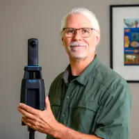
Professional photographer with 20+ years experience in real estate, architectural, and entertainment photography. BA in Radio & Television from SFSU. Published author of 'This Old Building: The Closing of Winterland'.
Questions
What real estate photography services do you offer?
We provide interior/exterior photography, twilight imaging, virtual tours, and drone photography to showcase properties comprehensively.
Do you serve areas outside Portland?
Our primary service area includes Clackamas and Multnomah Counties within the Portland Metro region.
What CAD accuracy standards do you follow?
Our floor plans meet ANSI certification with 1/4-inch measurement precision and AIA standard layering.
Can you create 3D models of properties?
Yes, we offer 3D modeling integrated with virtual tours and CAD drawings for immersive property visualization.
How do I book a photo session?
Contact us via phone or email to schedule shoots, with options for same-day appointments when available.
What file formats do you provide?
Clients receive DWG, RVT, PDF, and digital image formats with secure online file access.