Business Details
18 Years
experience
Professional Aerial Photography and Video Services
Founded in 2008, Above All Photography has established itself as the premier provider of aerial photography and videography services across the Midwest. Our team combines cutting-edge technology with decades of industry experience to deliver high-resolution imagery, dynamic video production, and precision mapping solutions. Specializing in aerial, ground, interior, and architectural photography, we serve commercial real estate developers, construction firms, engineering companies, and media production houses nationwide. Our fleet includes FAA-authorized drones, helicopters, and fixed-wing aircraft equipped with state-of-the-art cameras capable of capturing 5K video and 16MP stills. With satellite offices in St. Louis and Cleveland, we maintain rigorous quality standards while offering scalable solutions for multi-state projects.Our pilots hold commercial certifications with over 2,500 combined flight hours, ensuring safe and compliant operations. We pioneered stabilized aerial HD video production in the Midwest and continue to innovate through 3D compositing and georectification technologies. Clients benefit from our in-house graphic design and post-production expertise, delivering polished deliverables from concept to completion. Our commitment to technical excellence and customer satisfaction has earned us federal trademark protection for our brand. Whether capturing real estate portfolios, infrastructure projects, or Hollywood film sequences, we prioritize timeliness, quality control, and creative problem-solving to meet exact client specifications.
Services
Aerial Photography
Drone Videography
Helicopter Shoots
Mapping Surveys
3D Compositing
Interior Photography
Video Stabilization
Graphic Design
Printing Services
Lamination Mounting
Details
- Year established: 2008
Highlights and features
- We operate FAA-authorized drones with 5K video capabilities and 16MP resolution
- Our pilots hold commercial certifications with 2,500+ combined flight hours
- We pioneered stabilized aerial HD video production in the Midwest region
- We maintain 24/7 readiness for time-sensitive aerial documentation projects
- Our service areas span 30+ states with consistent quality across all locations
Services
Aerial Photography
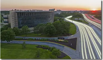
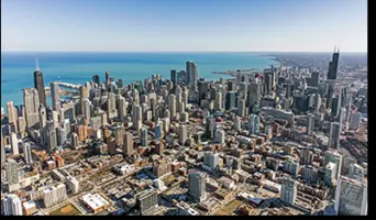
Our aerial photography services capture high-resolution images using FAA-compliant drones, helicopters, and fixed-wing aircraft. We specialize in oblique, vertical, and architectural photography for real estate, construction, and infrastructure projects. Clients receive precisely calibrated images with 6-pixel resolution and georectification capabilities for accurate mapping applications.
Drone Videography
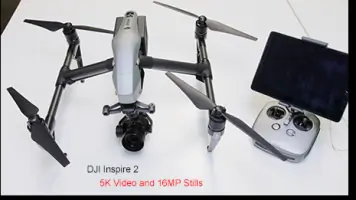
We produce stabilized 5K video content using DJI Inspire 2 drones with dual battery redundancy and 25-minute flight duration. Our drone videography captures dynamic perspectives for marketing materials, construction documentation, and entertainment productions while maintaining strict FAA regulatory compliance for urban operations.
3D Compositing
Our 3D compositing integrates aerial footage with Autodesk 3D Studio Max renderings to create photorealistic visualizations. This service enables clients to showcase proposed developments with accurate environmental context, combining Syntheyes camera tracking and After Effects compositing for architectural presentations and infrastructure planning.
Mapping Surveys
We conduct precision aerial mapping using true survey cameras with 1-foot resolution capabilities. Our services include planometric imaging, orthorectification, and mosaic creation for land development projects, utilizing specialized GPS equipment to ensure survey-grade accuracy for engineering and construction applications.
Video Production
Our broadcast-quality HD video production utilizes Panasonic HDX-900 cameras with Kenyon gyro-stabilization systems mounted in helicopters and airplanes. We provide raw footage capture, post-stabilization processing, and full editing services for commercial clients, media producers, and government agencies requiring professional aerial video content.
People
James Grumme
Owner / Photographer / Pilot
Indiana University graduate with B.S. in Informatics, specializing in IT Management. Certified Adobe Production Expert with 2,500+ flight hours as instrument-rated commercial pilot. Manages mapping projects and website development.
Kris Holthouse
Satellite Location Owner
Manages Cleveland, Ohio operations with expertise in aerial photography coordination and client relations. Ensures consistent quality standards across all satellite locations.
Questions
What aerial photography services do you offer?
We provide drone photography, helicopter and airplane aerial imaging, 3D compositing, mapping surveys, and interior/exterior architectural photography.
Which areas do you service?
We operate throughout the Midwest with satellite offices in St. Louis and Cleveland, and accept nationwide assignments across 30+ states.
What equipment do you use?
Our equipment includes DJI Inspire 2 drones, Cessna 206 aircraft, Robinson R-44 helicopters, and Panasonic HDX-900 cameras with Kenyon stabilizers.
Can you handle large multi-state projects?
Yes, we routinely manage assignments covering 20-30 states with guaranteed consistency through our network of FAA-authorized photographers.
What video production capabilities do you have?
We offer stabilized HD aerial video production, post-production editing, and 3D animation integration for commercial and entertainment clients.
Videos